
Drain Mapping Services
Fast-Response Drainage Experts — Trusted Since 1986
Need a detailed plan of your drainage system?
Get expert help today.

Instant Free Quote
No obligation, no hidden fees. Just a clear, honest price.
Accreditations

Your Local Mapping Experts in London & Hertfordshire...
Are you planning a renovation, buying a new property, or struggling with persistent drain problems? Understanding the layout of your drainage system is the essential first step.
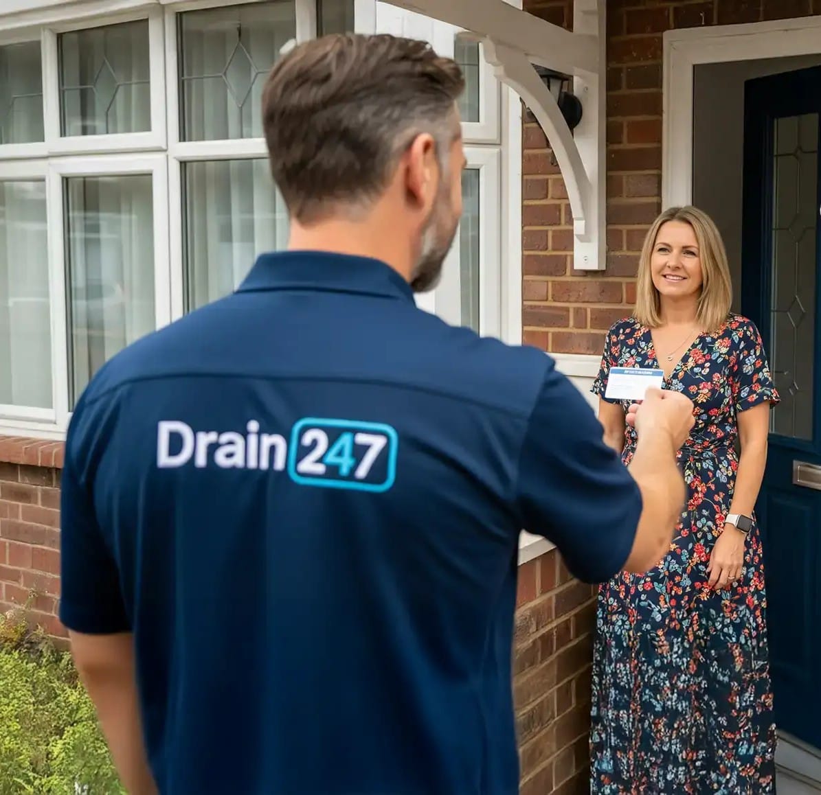
Drain 247 offers precise and accredited drain mapping and drain tracing services across London, Hertfordshire, and the surrounding areas, such as Watford, Bushey, St. Albans, Stevenage, Hatfield, Welwyn Garden City, Radlett, Elstree, and Borehamwood. Our advanced drain mapping and tracing services provide you with a detailed and accurate schematic of your entire drainage network. Using the latest CCTV, sonar, and GPS technology, we can pinpoint the exact location, depth, and condition of your pipes, sewers, and manholes.
What is Drain Mapping?
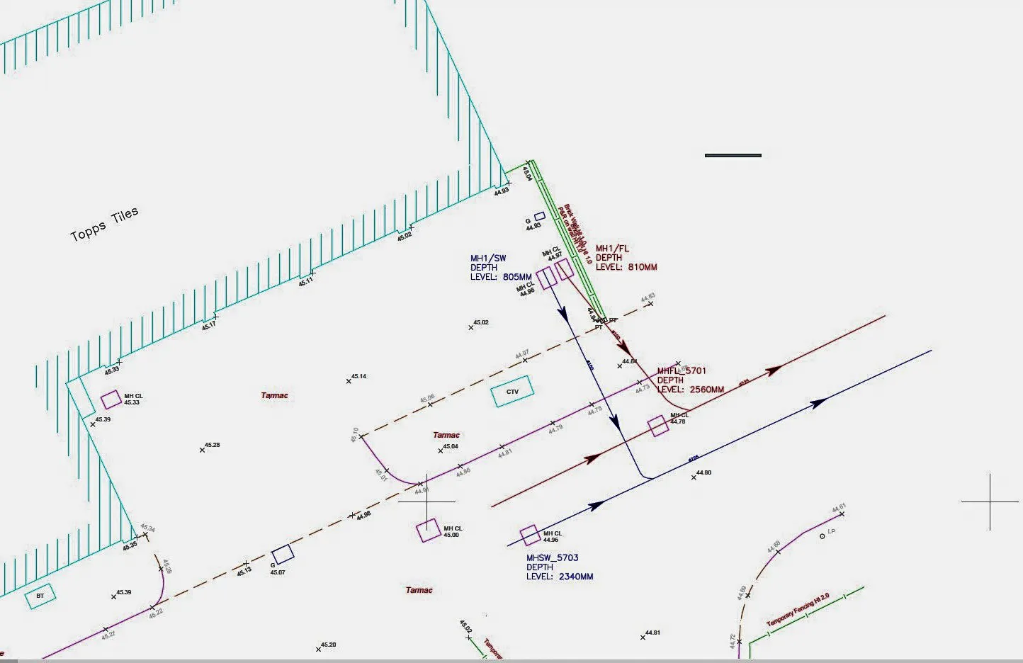
Drain mapping, also known as drain tracing, is the process of creating a comprehensive, detailed plan of your property’s underground drainage system. Using state-of-the-art CCTV cameras, sondes, and sonar tracing technology, we go beyond a simple sketch to produce an in-depth report that includes:
Pipe Location and Depth: The exact position of all foul and surface water drains, preventing accidental damage during construction or landscaping.
Pipe Condition: A full assessment of the material, diameter, and structural integrity of the pipework to identify potential problems like cracks or root intrusion before they escalate.
Flow Direction: A clear outline of how water and waste leave your property.
Manhole and Inspection Chamber Locations: The precise location and depth of all access points, crucial for future maintenance and repairs.
Connections: Identification of shared drains and your connection point to the public sewer, which is often required for legal purposes and Build Over Agreements.


Who Needs Drain Mapping?
An accurate drain map is a vital tool for a wide range of clients. Whether you’re managing a property, planning a build, or ensuring site compliance, our drain tracing service provides the essential data you need.
For Homeowners & Renovators
Planning an extension, buying a new home, or tired of recurring blockages? A drain map is your first step. It uncovers hidden issues before you buy and provides the necessary documentation for a Build Over Agreement, ensuring your renovation goes smoothly without damaging crucial pipework.
For Architects & Developers
Viable project designs depend on accurate data. Our detailed CAD plans provide the precise site information you need to design with confidence, meet planning requirements, and prevent unforeseen and expensive delays during the construction phase.
For Commercial & Industrial Site Owners
For your business, drainage isn’t just about flow—it’s about compliance and continuity. Our mapping services help you maintain adherence to environmental and safety regulations, and more importantly, prevent the costly operational downtime that results from unexpected system failures.
Our Full Range OfMapping Services
Our Drain Mapping Process
We’ve refined our process to be as efficient and non-disruptive as possible. Here’s what you can expect:
Step 1: Initial Consultation & Quote
We begin with a free, no-obligation chat to fully understand your requirements. Based on this, we provide a clear, fixed-price quote with no hidden fees.
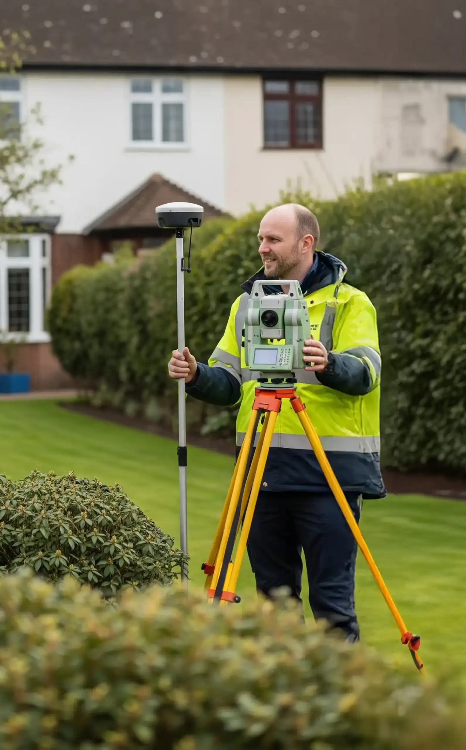
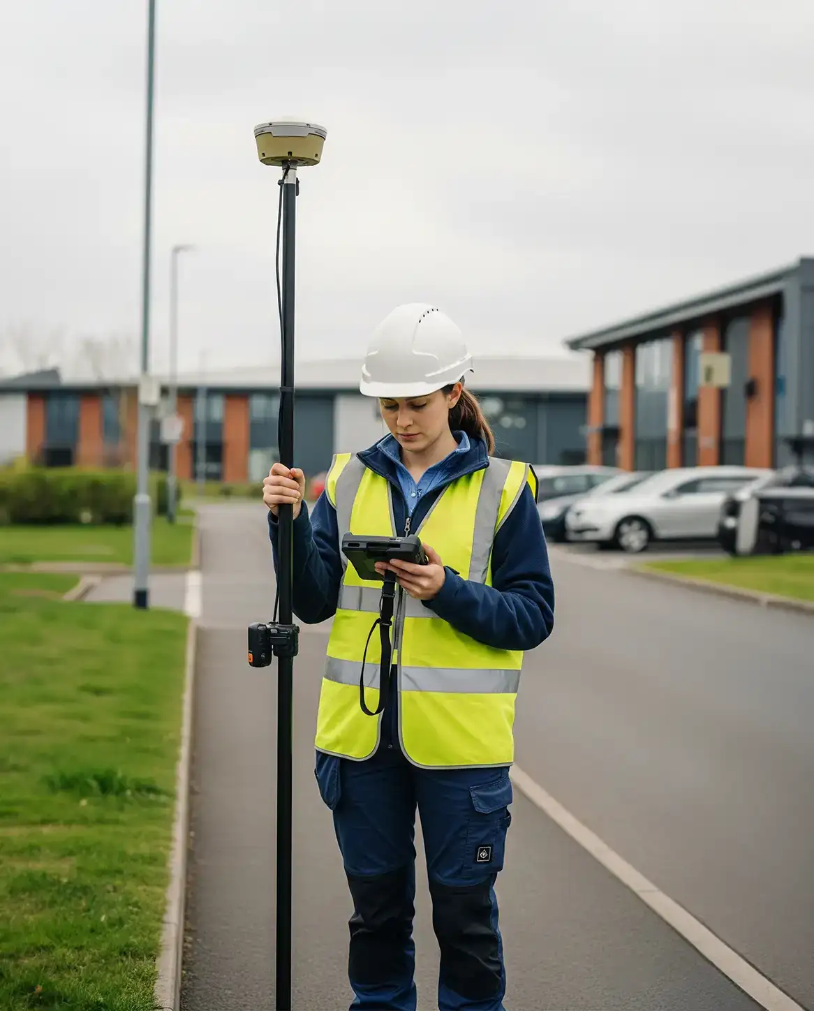
Step 2: Professional On-Site Survey
Our fully qualified and insured engineers will visit your property at a time that suits you. Using advanced CCTV and sonar equipment, we conduct a thorough, non-invasive survey of your entire drainage system.
Step 3: Detailed CAD Plan Creation
Our technical team processes the high-definition survey data to produce a precise and easy-to-read CAD (Computer-Aided Design) drawing of your drainage network.
Step 4: Full Report & Recommendations
You receive the complete package: your detailed CAD plan (in both PDF & DWG formats), a written summary of our findings, and a list of professional recommendations for any issues we identify. Most reports are completed and delivered within 48 hours of the survey.
What’s Included With Your Drainage Plan?
When you commission a drain map from Drain 247, you don’t just get a drawing; you get a complete, actionable intelligence report on your property’s drainage infrastructure. Your final package will include:
An Industry-Standard CAD Drainage Plan: A precise and detailed digital map of your entire system, including all foul, surface, and combined drains. Delivered in both PDF and DWG formats, it’s ready to be used by architects, builders, and local authorities.
Comprehensive Asset Data: The plan will clearly detail all critical information, including pipe materials, sizes, depths, and accurate manhole locations, giving you all the data needed for effective planning and maintenance.
An Actionable Written Report: Alongside the visual plan, you’ll receive a full written summary of our findings. This isn’t just data—it’s a roadmap. We’ll highlight any structural issues or defects found during the survey.
Professional Recommendations & Costings: To help you plan your next steps, our report includes clear, professional recommendations for any necessary repairs or improvements, complete with estimated costs. This empowers you to budget effectively and prevent future drainage emergencies.
Why is Drain Mapping Essential?
A drain map from our Watford team is more than a simple drainage plan; it’s a vital health check for your property’s hidden infrastructure.
Using advanced CCTV technology, we go beyond just locating pipes to diagnose the unseen issues that cause recurring problems and costly emergencies.
Our detailed surveys regularly uncover critical defects like hairline fractures, partial collapses, and invasive tree root damage before they escalate.
We identify the true source of chronic blockages that simple jetting can’t solve and provide the essential data needed for Build Over Agreements. This knowledge empowers you to move from reactive repairs to proactive management.
By pinpointing the exact location and nature of any issue, you can undertake targeted, cost-effective solutions, saving you from expensive guesswork and giving you complete control over your property’s long-term drainage health.
Need a Detailed Drain Map? Get Your Free, Fixed-Price Quote Today
5-Star Reviews.


Testimonial
Drain 247 mapping saved our project from delays. Clear plans, fast service!”
— John S, Architect, London
Why Choose Drain 247 for Your Mapping Needs?
We know you have a choice. Here’s why homeowners, architects, and businesses across Watford and Hertfordshire have trusted us since 1986.
Fixed-Price Guarantee: We provide clear, upfront fixed-price quotes for all our drain mapping services. You’ll never have to worry about hidden fees or surprise charges.
Industry-Leading Accreditations: We are fully accredited and insured, holding certifications from CHAS, Constructionline, and ISO. You can be confident you’re hiring qualified, vetted professionals.
True Local Expertise: We’re not a faceless national chain. As a Watford-based company, we have decades of experience with the specific drainage systems found in London and Hertfordshire properties, from Victorian terraces to new developments.
Actionable, Professional Reports: You don’t just get a map; you get a complete digital package (PDF & DWG files) with a written report and clear, costed recommendations, perfect for satisfying Build Over Agreements and planning repairs.
Contact
We are Here:
42-44 Clarendon Road, Watford, Hertfordshire, WD17 1JJ

Call Us:
Get in Touch
Your email address will not be published. Required fields are marked *
Areas We’ve Recently Worked In
London: Ealing, Chiswick, Hammersmith, Acton, Maida Vale, Cricklewood, Richmond, Twickenham, Barnet, Enfield, Finchley, Golders Green, Highgate, Clapham, Wimbledon, Romford, Stratford, Ilford, Kensington, Chelsea, and Westminster.
Hertfordshire: Watford, St Albans, Hemel Hempstead, Rickmansworth, Borehamwood, Welwyn Garden City, Hatfield, Harpenden, Radlett, Elstree.
Middlesex: Harrow, Uxbridge, Stanmore, Ruislip, Hendon, Wembley, Pinner, Northolt, Greenford, Ickenham, Colindale.
Frequently Asked Questions

How accurate is your drain mapping?
We use the latest equipment to measure to within a few centimetres to produce high-quality drainage plans, including invert levels, direction of flows, depth levels, and more. Our advanced technology ensures exceptional accuracy and detail, giving you reliable data for design, planning, and compliance purposes. This level of precision is essential for both new developments and maintenance of existing drainage systems.
What will I receive at the end of the mapping?
A full digital or AutoCAD drainage plan and summary report with drainage data, suitable for legal and planning uses, provides detailed drawings and supporting calculations that clearly show the proposed drainage layout for a site.
How long does a drain mapping survey take?
Most surveys completed within 24-48 hours and are sent directly to the homeowner, architect or developer.
Will you need to dig up my garden?
No. Our methods are non-invasive. We use existing manholes and access points, so there is no need for any disruptive digging.
I'm buying an older Victorian property in Hertfordshire. What hidden drainage issues can a pre-purchase map uncover?
Older properties, especially Victorian and Edwardian homes common in our area, often have original clay pipework that is prone to specific issues. A pre-purchase drain map is crucial for uncovering these costly hidden defects, such as displaced joints, pipe fractures from ground settlement, and extensive tree root ingress from mature gardens. We can also identify outdated or failing components like pitch fibre pipes, giving you a complete picture of the system’s health and potential liabilities before you finalise the purchase.
What is the difference between a standard CCTV drain survey and a full drain mapping service?
This is a key distinction. A standard CCTV drain survey is primarily a “condition report”—it sends a camera down the pipes to inspect their integrity and find blockages or defects. Drain mapping incorporates this CCTV data but adds a crucial second layer: we use advanced sondes and sonar tracing to pinpoint the exact physical location, depth, and route of the entire system from above ground. The end result isn’t just a video; it’s a comprehensive, scaled CAD plan of your entire drainage network.
My council requires a 'Build Over Agreement' for my extension. What specific information does a drain map provide for this?
A Build Over Agreement with your local water authority, such as Thames Water, requires a detailed technical blueprint of your existing drainage. Our drain mapping service is designed specifically for this. The final CAD plan and report provides the precise data they need to grant permission, including the exact location, depth, and condition of any shared or public sewers relative to your proposed foundations. It also details pipe diameters, flow direction, and manhole locations, proving your construction will not damage public assets or restrict future access.